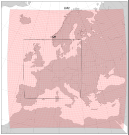
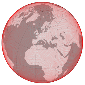
Meteorological models by DWD used for computation
Regional model ICON-EU since 2016-01-14
- non-hydrostatic, compressible detail model
- covering nearly entire Europe
- 659 156 surface grid points with nodal distances of ~6.5 km
- triangular cells of approx. equal size
- 60 layers with upwards increasing thickness (20 m .. 2800 m)
- constant height of 22.5 km
- 3 hours time interval
Regional model COSMO-EU from 2005-11-01 to 2016-11-30 (former name LM2):
- non-hydrostatic, compressible detail model
- covering nearly entire Europe
- 436 905 surface grid points with nodal distances of 7 km
- square cells of approx. equal size
- 40 layers with upwards increasing thickness (20 m .. 2800 m)
- constant height of 23.6 km
- parameters used: surface air pressure, temperature and specific humidity in each layer, geometrical height
- 6 hours time interval
- 3 hours time interval since 2012-02-23
Regional model LM1 (until 2005-10-31):
- covering Germany and neighboring countries
- 105 625 surface grid points with nodal distances of 7 km
- horizontal discretization same as in LM2
- 35 layers with upwards increasing thickness (70 m .. 2800 m)
Reference:
Steppeler, J., Doms, G., Schättler, U., 2003. Meso-gamma scale forecasts using
the nonhydrostatic model LM. Meteoro. Atmosph. Phys. 1/4, 75-96.
Global model ICON 384 (since 2014-12-04):
- global non-hydrostatic model
- basic grid structure identical to GME
- 2 949 120 surface grid points having an average spacing of 13 km
- triangular cells of nearly equal size
- 90 layers defined by pressure levels
- upper bound at approx. 75 km
- parameters used: surface air pressure (2D) and geopotential at all pressure levels (3D)
- 3 hours time interval
Global model GME 384 (2012-02-29 until 2015-02-22):
- global hydrostatic model
- 1 474 562 surface grid points having an average spacing of 20 km
- hexagonal/pentagonal cells of nearly equal size
- 60 layers defined by pressure levels
- heights given as geopotential surfaces
- vertically bounded by a zero pressure level at a height of approx. 36 km
- parameters used: surface air pressure (2D) and geopotential at all pressure levels (3D)
- 3 hours time interval
Global model GME 256 (2010-02-02 until 2012-02-28):
Difference to GME 384: horizontal discretization
- 655 362 surface grid points having an average spacing of 30 km
- 6 hours time interval
- 3 hours time interval since 2012-02-23
Global model GME 192 (2004-11-01 until 2010-02-01):
Difference to GME 256: horizontal and vertical discretization
- 368 642 surface grid points having an average spacing of 40 km
- 40 layers defined by pressure levels
- vertically bounded by a zero pressure level at a height of approx. 30 km
- 6 hours time interval
Global model GME 128 (until 2004-10-31):
Difference to GME 192: horizontal discretization
- 163 842 surface grid points having an average spacing of 60 km
- 6 hours time interval
Reference:
Majewski, D., Liermann, D., Prohl, P., Ritter, B., Buchhold, M., Hanisch, T.,
Paul, G., Wergen, W., Baumgardner, J., 2002. The operational global
icosahedralhexagonal grid point model GME: description and high resolution
tests. Mon. Wea. Rev. 130, 319-338.


